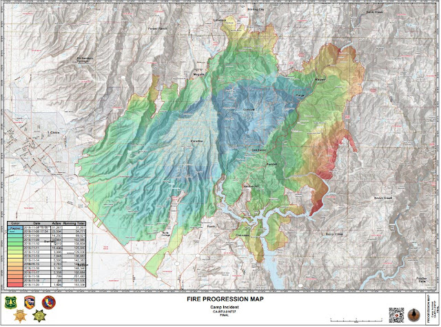
Camp Fire Map and Live Fire Radio from Butte County, California
Live News Coverage
Camp fire is the most destructive fire in California history. 42 people are confirmed dead. NorCal Residents Who Lost Homes in Camp Fire Sue PG&E for Allegedly Causing Deadly Blaze
Thousand Oaks & Westlake Fire Evacuation Maps & Live News
Mandatory Evacuation & Lifted Evacuation Areas / Check Points
Live News Coverage
Hawaii Volcano Lava & VOG Maps
Hawaii VOG Map
If you are planning to vacation or live on the Big Island in Hawaii VOG has always been an issue in various places around Kona and the southwest part of the Island. Depending on the winds the VOG can be an issue for people with breathing issues. See the live Hawaii VOG map here.
What is VOG? It is a smoke haze containing volcanic dust and gases. If the lava hits the ocean sometimes steam is created as well which also creates a VOG-like cloud.
The map model uses estimates of volcano emissions along with forecast winds to predict the concentrations of sulfur dioxide gas (SO2) and sulfate aerosol particles (SO4) downwind of the ongoing Kilauea eruption.
Here is a map of the Big Island Geothermal Power Plant threatened by the lava.
Popular Maps
-
Florida, known for its sunny beaches and warm climate, is also one of the most hurricane-prone states in the U.S. Understanding Florida'...
-
Flash floods are one of the most dangerous weather events, often occurring with little warning and resulting in severe damage. Flash flood...
-
Planning for tomorrow’s weather is more than convenience — it impacts agriculture, shipping, aviation, and even local events. But not all w...
-
In the adrenaline-fueled realm of storm chasing, a select group of individuals stand out as pioneers and experts in capturing nature's m...
-
Imagine a world where the electrical grid, the backbone of modern civilization, collapses entirely. No lights, no internet, no functioning ...
-
Natural disasters have increasingly shaped the trajectory of urban development and resilience...
-
NOAA Hurricane Storm Surge Map Potential Storm Surge Flooding Map in Fort Myers and Cape Coral Areas greater than 1-9 feet above the ground ...
-
Earthquakes are sudden reminders of the Earth’s restless nature. In 2020, while the world’s attention was focused on the global pandemic, ...
Topics
Fire
California
Hurricane
Calfire
Flood
Evacuation
Florida
Shelters
Google Maps
How To
Storm
Smoke
Weather
Air Quality
Map
Tornado
Government
ESRI
FEMA
Los Angeles
Earthquake
Wind
Insurance
Oregon
Hurricane Helene
Hurricane Ian
Video
Arson
Colorado
Hawaii
Iowa
Oklahoma
Red Cross
Salvation Army
Chasers
Data
Food Pantry
Forecast
Hurricane Harvey
Hurricane Milton
Midwest
Africa
Climate
Derecho
Hurricane Idalia
Live
Mobile App
Oil
Power
Satellite
Texas
Top10
Ventura
Volcano
Washington
AI
Canada
Cell Phone Towers
Coronavirus
CrisisMap
Fake News
Gulf of Mexico
Homeless
Louisiana
Puerto Rico
Radar
Tsunami
United Nations
United States
War
Alabama
Australia
Bel AIr
Beverly Hills
Calabasas
Caribbean
Cyclone
EPA
Gavin Newsom
Google
Houston
Hurricane Ida
Hurricane Laura
Hurricane Sally
Malibu
New Orleans
North Carolina
Orange County
Palisades
Prepare
Santa Clarita
Santa Monica
Santa Rosa
Sonoma County
Taxes
The Getty
Thousand Oaks
Trump
Typhoon
Virginia
Water
Wisconsin
Aerial
Anaheim
Antarctica
Arizona
Bahamas
Border
Camp
Canyon
Crash
Damage
Deductions
Explosion
Gas Buddy
Georgia
Greece
Hail
Hurricane Delta
Hurricane Dorian
Hurricane Florence
Idaho
Income
Kansas
Kentucky
LA Times
Mississippi
Missouri
Mudslide
NOAA
Napa
Nebraska
New York
Planning
Pollution
Poverty
Power Lines
Redding
Refinery
Relief
Sacramento
Skirball
Starlink
Strange
Sylmar
TV
Terrorist
Toxic Waste
Traffic
Trees
Ukraine
Westlake
Woolsey
Yorba Linda
Zogg


