

Hurricane Dorian Path of Destruction Map

Map of Hurricane Dorian path of destruction in the Bahamas and East Coast
US Flood Forecast Map Spring 2019

The National Weather Service issued its annual spring flood outlook. By the end of May, parts of 25 states nearly two thirds of the USA could see flooding severe enough to cause damage.
Every major body of water east of the Rockies is at elevated risk of flooding in the coming months, including the Mississippi, the Red River of the North, the Great Lakes, the eastern Missouri River, the lower Ohio, the lower Cumberland, and the Tennessee River basins.
NOAA Spring Flood Forecast.
Historic Midwest Flooding Spring 2019

Record Midwest Flooding
Map of US & Mexico Border Wall Gaps
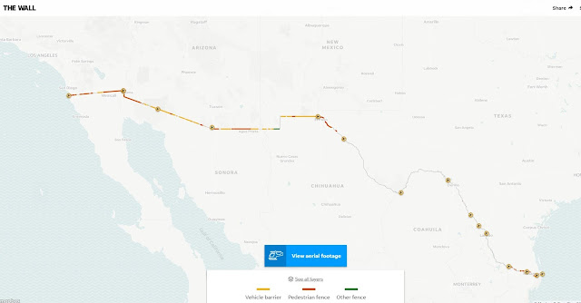
This map looks at every mile of the U.S.-Mexico border. Now you can, too – right here.
Popular Maps
-
Imagine a world where the electrical grid, the backbone of modern civilization, collapses entirely. No lights, no internet, no functioning ...
-
In the adrenaline-fueled realm of storm chasing, a select group of individuals stand out as pioneers and experts in capturing nature's m...
-
 How To Subscribe Visit the DisasterReliefMaps.com website. Sign in using your Google account to instantly access our extensive disaster...
 -
Every few years, the Pacific Ocean flips between two dramatic moods — one that warms the world, and one that cools it. Scientists call the...
-
In the battle against wildfires and arson, technology has emerged as a formidable ally, aiding in early detection, rapid response, and effec...
-
 The Hungarian RSOE and Its Emergency and Disaster Information Service (EDIS) Introduction When disasters strike, the difference between ...
 -
 Syndicated Maps Network of Map Apps How you add our web app to your iPhone home screen:
 -
Oppenheimer, a name that resonates with both the realms of science and finance, belongs to one of the most influential figures of the 20th c...
-
 Earthquakes are sudden reminders of the Earth’s restless nature. In 2020, while the world’s attention was focused on the global pandemic, ...


