Disasters rarely announce themselves in advance. From hurricanes and wildfires to earthquakes, floods, and even man-made events, millions of people each year are caught off guard. The consequences can be devastating—loss of life, property destruction, financial setbacks, and long recovery periods.
Planning for disasters isn’t about expecting the worst. It’s about building resilience, creating peace of mind, and giving yourself and your family the tools to respond effectively when emergencies strike. By taking the time to prepare now, you can protect lives, minimize damage, and speed up recovery.
July 30, 2025 — A major 8.7 magnitude earthquake has struck off the eastern coast of Russia near the Kuril Islands, prompting tsunami warnings across the Pacific. The quake occurred at a depth of approximately 35 km (21 miles), a level known to displace the seafloor significantly — a critical factor in generating tsunami waves.
📏 How Big Is a Magnitude 8.7 Earthquake?
An 8.7 magnitude earthquake is categorized as a “great” earthquake and ranks among the most powerful ever recorded. It releases energy equivalent to around 1,000 megatons of TNT — more than 30,000 times the energy of the Hiroshima atomic bomb.
Comparisons with other historic earthquakes:
2004 Indian Ocean Earthquake: 9.1–9.3 — triggered a devastating tsunami that killed 230,000+ people
2011 Japan (Tohoku): 9.0 — caused over 15,000 deaths and the Fukushima nuclear disaster
2005 Indonesia (Nias): 8.7 — produced a tsunami and killed hundreds
2025 Russia (Kurils): 8.7 — tsunami threat unfolding
🌐 Tsunami Wave Arrival Forecasts
Authorities have issued warnings, watches, and advisories for coastal areas across the Pacific. Below are the estimated tsunami wave arrival times:
Florida, known for its sunny beaches and warm climate, is also one of the most hurricane-prone states in the U.S. Understanding Florida's hurricane zone maps is crucial for residents, business owners, and travelers. These maps not only highlight the areas most at risk but also provide crucial information to help Floridians prepare for hurricane season.
In Florida, mandatory evacuations are issued when a serious threat to life and property is imminent, typically due to natural disasters like hurricanes, floods, or wildfires. These orders are crucial for the safety of residents, and understanding what a mandatory evacuation means and how to prepare for it can make a life-saving difference.
In this video, we are talking about Hurricane Idalia and it’s upcoming rapid intensification. Live Hurricane Idalia Video & Updates. This storm will make landfall tomorrow a.m. at 8:30 Eastern.
As the sun sets on powerful developing #Idalia dangerous storm surge is heading north. The water will rise overnight and in the morning in many areas along Florida's west coast. Be safe all. pic.twitter.com/kgawvn5xj8
The Dixie Fire moves into the top 10 of largest wildfires in state history
Evacuation Map
Dixie Fire West Zone:Fire continues to move toward control lines burning unburned interior islands and ridges. Steep terrain, heavy fuel loading, and wind in alignment with canyons is making control difficult. Fire activity continued into the evening hours following local winds and topography with active uphill runs, flanking, and single tree torching. Hot conditions will persist this afternoon across the fire area. Winds are beginning to respond with southerly and westerly winds becoming more prevalent gusting up to 20 mph. Afternoon humidity will continue to plummet into the teens across many locations. Crews continue to fight fire aggressively, construct and reinforce control lines, and protect structures. Mop up efforts have begun where appropriate.
Dixie Fire East Zone: The fire grew north with active burning due to Red Flag weather conditions yesterday afternoon. No additional structure damage has been reported. Mandatory evacuation orders have been updated to include areas north of Greenville and Lake Almanor. Overnight poor relative humidity recovery and dry conditions contributed to fire activity while crews monitored and patrolled the fire perimeter. Today hot, dry and windy conditions are predicted with a Red Flag warning in effect at 1 pm until Thursday at 8 pm. Active fire behavior is expected with strong, gusty winds. Today crews are building direct, indirect and contingency lines where
the fire is active. Firefighters will be mopping up and patrolling the rest of the perimeter of the east zone diligently checking for fire movement.
Both the CalWood and Lefthand Canyon fires increased containment on Wednesday with minimal fire growth. The CalWood Fire is now 24% contained and the Lefthand Canyon Fire is 43% contained. Yesterday, crews on the southeast edge of the CalWood Fire conducted a successful tactical burn operation near the Balarat Education Center to protect structures in that area and connect constructed fire lines. Firefighters continued working in the Highway 7 corridor and along the northern edge of the fire constructing direct line and checking the progress of the fire to the north. Last night’s night shift was successful in holding the fire to minimal growth despite the overnight Red Flag Warning that brought warm temperatures and high winds to the ridgetops.
Firefighters on the CalWood Fire will continue yesterday’s work in all divisions. Crews on the southeastern side of the fire continue to build line as the fire backs down the hill towards Spruce Gulch. On the southwestern side of the fire, crews will patrol the area near yesterday’s firing operation. On the north side of the fire, crews will continue working on the canyon’s edge and in the Highway 7 corridor with the intent of keeping the fire south of Highway 7. Crews on the northeast side of the fire will continue constructing and patrolling fire lines.
Firefighters were able to secure the southern edge of the Lefthand Canyon Fire on Wednesday and no new growth was recorded after midday yesterday. Crews working on the north side of the fire continued mopping up and improving containment lines. Further increases in containment will come as additional containment lines are secured.
Weather & Fuel Conditions: A cold front arrived over the fire area early this morning and will continue moving into the area throughout the day. Temperatures will fall through the afternoon, dropping below freezing after sunset. Humidity will also be increasing over both fires today, rising to 60-70% over the course of the day. The changing weather conditions are also expected to temper fire activity today.
Extremely dangerous #CalwoodFire just north of Boulder, CO directly affecting WUI right now. I have observed multiple large fire vortices and a large, rotating pyrocumulus column. Wow. #COwxpic.twitter.com/BCnUhMIScn
On August 13, the Cameron Peak fire in the Arapaho and Roosevelt National Forests between Cameron Pass and Chambers Lake erupted. It burns over rough terrain in thick timber stands. Fire development has been propelled by high winds combined with critically dry fuels. There are evacuations and closures in place.
For each county above, you can check out interactive maps, evacuation orders, alerts, and school closures:
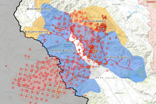
As the Glass Fire continues to expand, parts of Napa and Sonoma counties are under evacuation orders and/or warnings Monday.
In the already scorched area, strong winds fanned flames, burning homes and prompting overnight evacuation orders affecting more than 50,000 people.
According to Cal Fire, the Glass Fire (which also involves the combined Shady and Boysen fires in Sonoma County) has burned 11,000 acres and remains at 0 percent containment at last review.
The Glass Fire first broke out on Sunday in Napa and has spread to Sonoma since then.
The fires in the popular wine country of Napa-Sonoma came as the region approached the third anniversary of the Tubbs Fire that erupted in 2017. About a month earlier, several of the same people were evacuated from a lightning-sparked fire path that had become the fourth-largest in state history.
Mandatory evacuation orders were issued before midnight Sunday for the following zones in and on the outskirts of Santa Rosa:
Calistoga North
Calistoga South/Skyhawk
Pythian
Melita
Stonebridge
Oakmont North
Oakmont South
For those driven from their homes by the Shady Flames, Sonoma County and the city of Santa Rosa have set up multiple emergency evacuation points:
Glass Fire: Never wait til the last second to evacuate. This video is from Deputy Matt Macomber, one of several deputies currently evacuating parts of Napa County. pic.twitter.com/YQXFirJ0aV
County Fire, County Pawnee Fire, Pawnee Fire Perimeter, Canyon Fire, Creek Fire, Creek Fire Perimeter, Lane Fire, Lane Fire Perimeter, Upper Colony Fire, Lions Fire, Cherry Fire, Flat Fire
Flat Fire Perimeter, Creek Fire, Petersburg Fire, Woosley Fire, Camp Fire