
Blue Ridge Fire & Evacuation Maps Chino Hills & Yorba Linda, CA
Blue Ridge Fire in Yorba Linda grows to 3,000 acres; more than 15,000 people evacuated
East Troublesome Fire & Evacuation Map Near Lake Granby
Grand County, Colorado East Troublesome Fire explodes to 125,677 acres.

These areas are also currently under mandatory evacuation orders:
- All areas west of Highway 34
- All areas north of milepost 2 on Highway 34 to Rocky Mountain National Park
- Trail Creek subdivision - Area I
- Both sides of Hwy 125 from milepost 5 to the Grand/Jackson line
- Sheriff Creek / Kinney Creek area
An evacuation center was set up at the Inn at Silver Creek in Granby. Anyone forced to evacuate was asked to register using East Troublesome Fire Evacuee(s) Registration Form to assist with the re-entry process, the GCSO said. 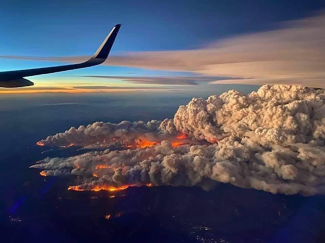


Calwood Fire Map & Evacuation Boulder, Colorado
Both the CalWood and Lefthand Canyon fires increased containment on Wednesday with minimal fire growth. The CalWood Fire is now 24% contained and the Lefthand Canyon Fire is 43% contained. Yesterday, crews on the southeast edge of the CalWood Fire conducted a successful tactical burn operation near the Balarat Education Center to protect structures in that area and connect constructed fire lines. Firefighters continued working in the Highway 7 corridor and along the northern edge of the fire constructing direct line and checking the progress of the fire to the north. Last night’s night shift was successful in holding the fire to minimal growth despite the overnight Red Flag Warning that brought warm temperatures and high winds to the ridgetops.
Firefighters on the CalWood Fire will continue yesterday’s work in all divisions. Crews on the southeastern side of the fire continue to build line as the fire backs down the hill towards Spruce Gulch. On the southwestern side of the fire, crews will patrol the area near yesterday’s firing operation. On the north side of the fire, crews will continue working on the canyon’s edge and in the Highway 7 corridor with the intent of keeping the fire south of Highway 7. Crews on the northeast side of the fire will continue constructing and patrolling fire lines.
Firefighters were able to secure the southern edge of the Lefthand Canyon Fire on Wednesday and no new growth was recorded after midday yesterday. Crews working on the north side of the fire continued mopping up and improving containment lines. Further increases in containment will come as additional containment lines are secured.
Weather & Fuel Conditions: A cold front arrived over the fire area early this morning and will continue moving into the area throughout the day. Temperatures will fall through the afternoon, dropping below freezing after sunset. Humidity will also be increasing over both fires today, rising to 60-70% over the course of the day. The changing weather conditions are also expected to temper fire activity today.
Extremely dangerous #CalwoodFire just north of Boulder, CO directly affecting WUI right now. I have observed multiple large fire vortices and a large, rotating pyrocumulus column. Wow. #COwx pic.twitter.com/BCnUhMIScn
— Daniel Swain (@Weather_West) October 17, 2020

Cameron Peak, Colorado Fire & Evacuation Maps
On August 13, the Cameron Peak fire in the Arapaho and Roosevelt National Forests between Cameron Pass and Chambers Lake erupted. It burns over rough terrain in thick timber stands. Fire development has been propelled by high winds combined with critically dry fuels. There are evacuations and closures in place.

Gulf of Mexico Tropical Storm Delta Expected to Become Hurricane
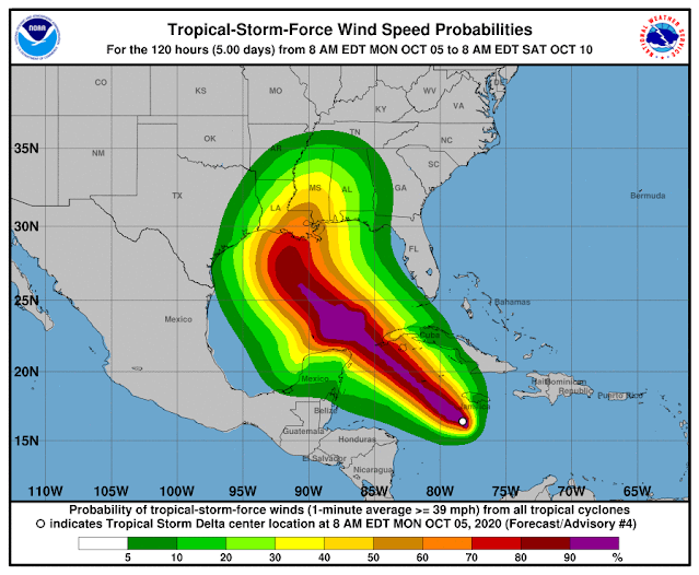
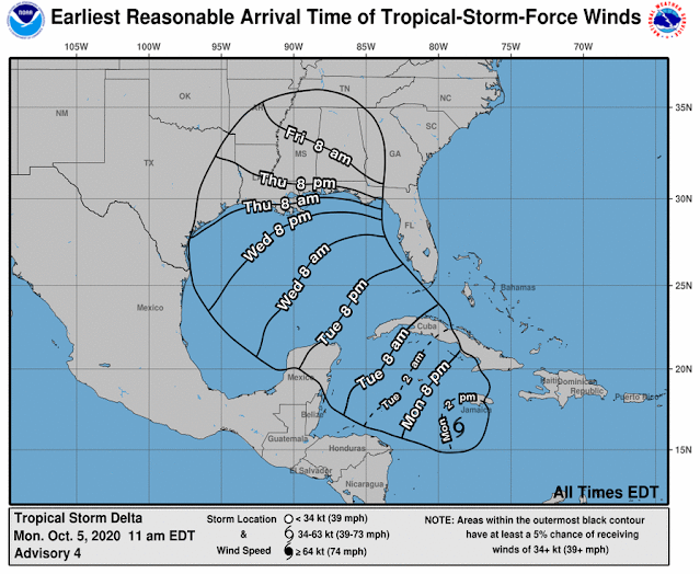
Tropical Storm Delta was approximately 135 miles south of Negril, Jamaica, as of 10 a.m., and approximately 265 miles southeast of Grand Cayman. The long-term track, which often changes, has the storm making landfall Friday near Terrebonne and Lafourche parishes and then turning east toward New Orleans and then heading into Mississippi.
At 7 mph, the storm is going west. Speed is expected to pick up on Tuesday and Wednesday. The core of the storm is predicted to move away from Jamaica later in the day on the forecast route, move close to or over the Cayman Islands on Monday night, and reach the Isle of Youth and western Cuba on Tuesday afternoon or evening.
In the Caribbean Monday morning, Tropical Storm Delta was strengthening and is predicted to become a hurricane Tuesday on its way towards Louisiana, forecasters said.
In southeast Louisiana, the latest track from the National Hurricane Center has Delta making landfall Friday as a Category 2 hurricane, but this far away, the route has an average error of 160 to 200 miles.
Depending on the direction and strength of the system, heavy rain, hazardous storm surge, and gusty winds are all possible along the coast from Louisiana to the western Florida panhandle, forecasters said. For residents, now is the time to make arrangements and prepare.
Tropical Storm Gamma, weakening in the Gulf of Mexico, is also being watched by forecasters. It is near the peninsula of Yucatan and is not supposed to enter the U.S. Gulf Coast.
Forecasters said the long-term track becomes complex because they are unsure how Tropical Storm Delta will interact with the remnants of Tropical Storm Gamma.
The interaction "could result in a sharp westward jog, after which a sharp turn back toward the northwest could occur," according to Stacy R. Stewart, a senior hurricane specialist with the National Hurricane Center.
The latest track from the National Hurricane Center has the system moving into the southeastern Gulf of Mexico Tuesday night or early Wednesday.

Free Disaster Relief Mobile Web App

Stay informed about hurricanes, typhoons, floods, fires, and other natural disasters near you.

Add Free Map to Home Screen for Easy Access

How to Add Button to Home Screen
When you open the map it will automatically find your location and display data relevant to your area. Each map has its own unique icon depending on which data you are interested in. The default map is all cameras but you can choose speed cameras, red-light cameras, traffic cameras below.
Syndicated Maps has a network of 25 public safety & location-based maps that you can easily find and add to your phone at the link above or by clicking on the phone apps screenshot above.

Syndicated Maps Network of Map Apps
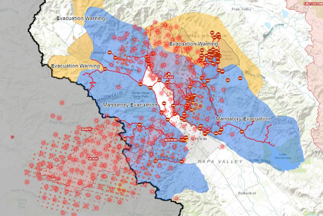
Napa Fire & Evacuation Map
For each county above, you can check out interactive maps, evacuation orders, alerts, and school closures:
As the Glass Fire continues to expand, parts of Napa and Sonoma counties are under evacuation orders and/or warnings Monday.
In the already scorched area, strong winds fanned flames, burning homes and prompting overnight evacuation orders affecting more than 50,000 people.
According to Cal Fire, the Glass Fire (which also involves the combined Shady and Boysen fires in Sonoma County) has burned 11,000 acres and remains at 0 percent containment at last review.
The Glass Fire first broke out on Sunday in Napa and has spread to Sonoma since then.
The fires in the popular wine country of Napa-Sonoma came as the region approached the third anniversary of the Tubbs Fire that erupted in 2017. About a month earlier, several of the same people were evacuated from a lightning-sparked fire path that had become the fourth-largest in state history.
Mandatory evacuation orders were issued before midnight Sunday for the following zones in and on the outskirts of Santa Rosa:
- Calistoga North
- Calistoga South/Skyhawk
- Pythian
- Melita
- Stonebridge
- Oakmont North
- Oakmont South
For those driven from their homes by the Shady Flames, Sonoma County and the city of Santa Rosa have set up multiple emergency evacuation points:
- Sonoma-Marin Fairgrounds, Petaluma, 175 Fairgrounds Drive.
- Building for Petaluma Veterans, 1094 Petaluma Blvd. Petaluma, South.
- The Veterans House of Santa Rosa, 1351 Maple Ave., Santa Rosa.
- A Spot to Park Tennis, 2375 W. Santa Rosa, 3rd St.
- Raceway Sonoma, 29355 Arnold Drive, Sonoma.
Rough Night/morning in east Santa Rosa as the #ShadyFire impacts Mountain Hawk Drive. @NorthBayNews pic.twitter.com/V2LC5popcx
— Kent Porter (@kentphotos) September 28, 2020
Glass Fire: Never wait til the last second to evacuate. This video is from Deputy Matt Macomber, one of several deputies currently evacuating parts of Napa County. pic.twitter.com/YQXFirJ0aV
— Napa County Sheriff's Office (@NapaSheriff) September 27, 2020
Zogg Fire & Evacuation Map in Redding, CA
According to Sheriff Eric Magrini, three people have died due to the Zogg Fire in Shasta County. Magrini gave no further information about those who died. Magrini said the fire forced about 1,250 people out of their homes, but those numbers could increase with the fire spreading rapidly.
An update on the Zogg Fire burning in Shasta County is being given by officials with the Cal Fire Shasta-Trinity Unit (Cal Fire SHU).
According to Cal Fire, the fire is still at least 15,000 acres and zero percent contained.
Evacuations are for the following areas:
- All areas south of South Fork Road and Zogg Mine Road. South along Gas Point corridor, including Gas Point Road to Foster Drive.
- All residents west of Zogg Mine Road.
- Platina Road to Tehama County line.

California Wildfire Burn Damage Seen From Space

New satellite imagery of California reveals not just the extent of its wildfire damage, but the depth of the loss.
The maps derived from the satellite data show how far two major fires spread as well as how badly each region burned. Darker colors represent near-complete loss — charred landscapes with little to no living vegetation left. Lighter tan regions represent areas where the fire was severe, but some trees and plants still survive.
The satellite data was collected by Landsat 8 on Sept. 26, during a clear day after weeks of smoke that blanketed the Bay Area.
 |

Air Quality Maps Compared: AirNow, AirVisual & Weather.com


Why is the Air Quality reading on Weather.com consistently different than AirNow and AirVisual?
Via my phone's default weather app, which uses weather.com, I received air quality readings. I downloaded IQAir AirVisual recently, and I've been puzzled by the fact that the reading of weather.com is consistently much higher.
For example, right now, I see the following readings:
- weather.com: 113 (I believe this is some sort of composite score)
- IQAir AirVisual: 42 (US AQI; this seems to be based on the same sensor as the one below)
- AirNow: 49 (NowCast AQI)
- AirNow Fire and Smoke Map: 27 (NowCast AQI; based on PurpleAir low-cost sensor)
These scores are all pretty poor right now, so it seems a little insignificant, but weather.com and AirVisual were both triple digits as recently as yesterday, with the weather.com reading sometimes reaching 200 due to the wildfires.
Answer:
The fire and smoke map of AirNow shows purple air sensor info but corrects it using an equation created after years of side-by-side research compared to official monitoring stations. Raw purple air data has high biases at high levels of smoke. Many 3rd party apps pull the raw purple data so that higher values are usually displayed. Daily AirNow, without any feedback from sensors, uses only official monitoring stations to craft the AQI. Data of higher quality but less coverage.
AQI or air quality index is a combination of variables and a formula to combine them into one number. Low numbers are good. Look for PM 2.5 numbers and compare them. They use different methods to calculate AQI with a large component being PM 2.5.
7 Reasons Why FEMA Denied You For Wildfire Disaster Assistance

How you can appeal if you are FEMA denied wildfire or flood disaster assistance.
Best Air Quality Maps Near Me - Mobile Web Apps
Air Quality Aware - Esri
ESRI Uses Map Data from Air Now
Esri, a mapping software platform based in California, said this week that it has introduced a new app, Air Quality Aware, which helps people understand the air quality in their city. The new all uses data from the EPA's AirNow program and the NOAA's National Weather Service, along with the American Community Survey. The new all-show areas, according to the organization, are color-coded according to the Air Quality Index of the EPA, with magenta and purple reflecting harmful and extremely unhealthy air quality.
The new web-based map joins other utilities such as PurpleAir, allowing users to see what air quality is in their area, as well as various local government agency locations. In recent weeks, interest in monitoring air quality has increased dramatically, as wildfires in the Western US have brought air quality to its worst in decades in many areas; smoke from those fires has now entered Europe.


Hurricane Sally Storm Surge & Flooding Forecast
Hurricane Sally floods Gulf Coast as officials urge residents in low-lying areas to 'run from the water'
Slow-moving storm Hurricane Sally is intensifying as swirls over the Gulf of Mexico towards Mississippi and Louisiana. The whirling center of Hurricane Sally may be slowly making its way toward the northern Gulf Coast, but the storm's heavy rains and wind have already caused widespread flooding in the area. The U.S. National Hurricane Center (NHC) in Miami said as of midday Tuesday, Hurricane Sally is a Category 1 storm, packing maximum sustained winds of 80 mph, and is located about 115 miles south of Mobile, Ala., "inching" northwest at 2 mph. Sally should reach land near the Alabama-Mississippi state line by late Tuesday or early Wednesday, bringing the threat of a storm surge of up to 7 feet along Alabama's coast, including Mobile Bay.
Life-threatening storm surge from Hurricane #Sally is expected from the Mouth of the Mississippi River to the Okaloosa/Walton County Line in the Florida Panhandle. Highest inundation expected along the Alabama coast, including Mobile Bay. https://t.co/IGqyxeC0LO pic.twitter.com/YAIwVflMBb
— National Hurricane Center (@NHC_Atlantic) September 15, 2020
Smoke & Haze from West Wildfires Reaches Midwest


 |
| Satellite Smoke Map |
Have you noticed the sun looks a little more orange than usual? In the skies of Northeast Wisconsin, smoke from wildfires is creating hazy conditions in the western US. FOX 11 Meteorology Director Pete Petoniak says the smoke from those fires is carried by upper-level winds thousands of miles away, making the skies appear milky around here.
The haze also makes for some vivid sunrises and sunsets. The smoke filters out shorter wavelengths of light, leaving mainly orange and red shining through.
Two recent photos of the United States were taken by the NPP satellite and both photos indicate that the winds have shifted again, pushing the smoke back to the East from western fires and crossing the continental USA. Tiny air-suspended particles (aerosols) are also carried along the jet stream alongside the smoke and carry unhealthy air quality across the world. The picture on the left depicts the whole of the United States and the smoke cloud that hangs over much of it
The picture to the right shows the aerosols that go with the smoke. Aerosols are a mixture of small particles and chemicals formed by incomplete burning of materials that contain carbon, such as trees, grasses, peat, brush, etc. All smoke includes particulate matter, carbon monoxide, and carbon dioxide. The smaller the particles, the easier to inhale and absorb them into the lungs. From the EPA website: "Small particles pose the greatest health hazard from the smoke. They can cause a variety of health issues, from burning eyes and a runny nose to exacerbated chronic heart and lung diseases. Particle pollution exposure is even associated with premature death.
West Coast Smoke Could Be Killing Thousands of Birds

Map of Reports Seeing Mass Dead Birds
Witnesses and researchers said some of the birds appeared to be acting bizarrely before dying — ones that usually hang in shrubs were spotted on the ground searching for food. Scientists are asking the public to report sightings of dead birds to an online database, and that people safely collect the dead birds so that researchers can study them closer.
New Mexico, Colorado, Arizona, and Texas are also reporting similar situations and large amounts of dead birds.

President Trump Visits With CalFire & Gavin Newsom
President Trump visits with CalFire and Gavin Newsom in Sacramento to see the damage from the California wildfires
Why did Gavin Newsom look so nervous in this meeting with Trump?


What Is The Best Mask For Smoke?

N95 Smoke Mask
A good smoke mask protects against poor air quality, but not all face masks are effective at preventing smoke inhalation. Experts say it's best for those who don't want to inhale harmful pollutants, no matter what mask you wear.
There are a variety of respirators, but the one that works best against brush fire smoke is the N-series. If you need more protection, an N95 respirator provides adequate protection for most people. Overall, the N99 Smoke Mask is a good choice, good enough to shield you in the event of a conflagration or something. Overall, it is important to be aware of the different types of smoke masks available to you, and you should not miss them.
There are hundreds of vendors selling smoke filters and masks, mainly in Asia, but there are also in North America, Europe, Australia, New Zealand, South America, and Africa. One of the best I have personally encountered is the N95 Smoke Mask, which is available from a number of vendors in the United States, Canada, and Australia.
As you can see, a gas mask alone is not an ideal solution when it comes to protecting a person from smoke and fire, but it can be very effective in combination with other smoke filters and masks to improve their effectiveness. There are washable smoke masks that have two valves that prevent moisture from accumulating on the mask and are ideal for people who do a lot of physical activity. Last but not least, gas masks have a built-in respirator, which can make them particularly effective when they are protected from the smoke.
Fabric masks are not recommended to prevent smoke and dust, as they tend to have poor filtration according to the California Department of Health. They are not there to protect children from smoke or dust and, worse, the particles in the bushfire smoke can cause respiratory problems if they are "too fine. Certified N95 masks are designed for children as they can filter out smoke and ash particles and improve air quality for adults.
If you are looking for a highly efficient disposable mask, the face mask is a good choice for you. You will also find N99 masks that filter out 99% of particles, and you must bear this in mind when looking for a mask with a high level of protection, such as the N95 mask or the N100 mask.
You cannot simply wear a surgical paper mask or a cloth mask and protect yourself from the fine particles. If you don't have a proper mask, a dust mask is better than nothing, even if it's not airtight. Smoky air penetrates when you breathe and destroys the whole purpose. While you are trying to filter out the hazardous chemicals and particulate smoke, if the mask is not airtight, you can still get some of the particles in, so that larger particles can be in the air. The gap between the skin and the mask can cause you to be between the gaps between you and the mask.

What Is A Derecho?

According to the National Weather Service, a derecho storm is a widespread, long-lived wind storm that is accompanied by a band of rapidly changing showers or thunderstorms. A derecho is a group of long-lived winds and storms associated with rapidly changing thunderstorms or showers. Derecho is the name for a wide range of widespread and long-lived wind storms, which are linked in bands with rapidly changing showers and thunderstorms.

Active Colorado Wildfires Maps
Colorado Current Wildfire Maps

Carmel Fires Map
The Carmel Fire in the area of Cachagua and Carmel Valley roads, south of Carmel, has burned 6,695 acres, according to Cal Fire. It is 15% contained.

Iowa Crop Damage Satellite Images Map

Iowa Derecho Corn Damage

Iowa Crop Damage Satellite Map
A highlighted area shows where some of the swaths of damage to farmlands were located, spanning in a line from west to east.

Iowa Crop Damage Satellite Map
Derecho insanity today in the Midwest. My goodness. pic.twitter.com/XGGubYYMf2— Dakota Smith (@weatherdak) August 10, 2020
Iowa Derecho Storm Maps & Damage

Huge storms produced widespread hurricane-like severe wind damage across Iowa, northern Illinois, and northern Indiana during the day on Monday, August 10. Much of this severe wind was significant (75+ mph winds) resulting in many downed trees, several toppled-over semi-trucks, cornfields, and many communities receiving at least some minor structural damage. Within the broader area of severe winds, 15 tornadoes were confirmed across northern Illinois and northwest Indiana. What is a Derecho?
New Site CoronaFraud.com Launches

We just launched a new site today to highlight coronavirus frauds, scams, and misbehavior caused by the virus and Government regulations.
In a world where most things are a scam and frauds these days. We are going to explore the following topics:
1) Payment Protection Loans
2) Small Business Issues
3) Companies & Products Scams
4) Tax Scams
5) Test, Medical & Doctor Scams
6) Censorship
7) Banks
8) Opposing Views
9) Data
10) Fake News
Here are the latest CoronaFraud.com posts below . . .
Map of High Risk Unemployment US Counties
Map of County employment risk, urban exodus, hospital bed availability, telehealth access, broadband availability & nationwide cases.
The impact of COVID-19 will vary across areas based on their industrial composition. In our analysis, we have focused on four industrial sectors which we expect are at higher risk of disruption. Data source: Center for Rural Innovation.
● Tourism
● Manufacturing & Wholesale
● Transportation
● Oil, gas, and coal production
The industry is sensitive to consumer demand. Sectors like manufacturing, wholesale, transportation (of goods), and oil, gas, and coal production are all likely to see declines due to decline in consumer demand and employment caused by the stay-in-place policies and the uncertainty created by the COVID-19 pandemic.
Calculating our employment risk index
1. The share of small business employment
2. The share of older high risk workers
3. The share of employment in industries likely to experience high volatility
Most people are not aware of how large the oil and gas industry is and how many people in rural America are employed in the energy sector. Here is a map of oil and gas drilling industry and you will see how it overlaps very nicely with this data. This can be found at DrillingMaps.com.
Maps of Kobe's Helicopter Flight Path, Air Traffic Control & Weather


Helipads colored
Air Traffic Control & Visual Flight Reference Flight Map

Popular Maps
-
How do we measure air quality?
-
 Why is the Air Quality reading on Weather.com consistently different than AirNow and AirVisual? Via my phone's default weather app, whic...
 -
Planning for tomorrow’s weather is more than convenience — it impacts agriculture, shipping, aviation, and even local events. But not all w...
-
Imagine a world where the electrical grid, the backbone of modern civilization, collapses entirely. No lights, no internet, no functioning ...
-
 Colorado Current Wildfire Maps Colorado wildfires in Pine Gulch, Grizzly Creek, Cameron Peak, Williams Fork, Lewiston, and Thorpe ...
 -
 How To Subscribe Visit the DisasterReliefMaps.com website. Sign in using your Google account to instantly access our extensive disaster...


-06-27-2023.png)


