
Blue Ridge Fire & Evacuation Maps Chino Hills & Yorba Linda, CA
Blue Ridge Fire in Yorba Linda grows to 3,000 acres; more than 15,000 people evacuated
East Troublesome Fire & Evacuation Map Near Lake Granby
Grand County, Colorado East Troublesome Fire explodes to 125,677 acres.

These areas are also currently under mandatory evacuation orders:
- All areas west of Highway 34
- All areas north of milepost 2 on Highway 34 to Rocky Mountain National Park
- Trail Creek subdivision - Area I
- Both sides of Hwy 125 from milepost 5 to the Grand/Jackson line
- Sheriff Creek / Kinney Creek area
An evacuation center was set up at the Inn at Silver Creek in Granby. Anyone forced to evacuate was asked to register using East Troublesome Fire Evacuee(s) Registration Form to assist with the re-entry process, the GCSO said. 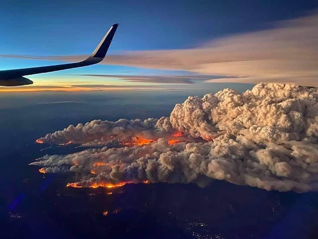


Calwood Fire Map & Evacuation Boulder, Colorado
Both the CalWood and Lefthand Canyon fires increased containment on Wednesday with minimal fire growth. The CalWood Fire is now 24% contained and the Lefthand Canyon Fire is 43% contained. Yesterday, crews on the southeast edge of the CalWood Fire conducted a successful tactical burn operation near the Balarat Education Center to protect structures in that area and connect constructed fire lines. Firefighters continued working in the Highway 7 corridor and along the northern edge of the fire constructing direct line and checking the progress of the fire to the north. Last night’s night shift was successful in holding the fire to minimal growth despite the overnight Red Flag Warning that brought warm temperatures and high winds to the ridgetops.
Firefighters on the CalWood Fire will continue yesterday’s work in all divisions. Crews on the southeastern side of the fire continue to build line as the fire backs down the hill towards Spruce Gulch. On the southwestern side of the fire, crews will patrol the area near yesterday’s firing operation. On the north side of the fire, crews will continue working on the canyon’s edge and in the Highway 7 corridor with the intent of keeping the fire south of Highway 7. Crews on the northeast side of the fire will continue constructing and patrolling fire lines.
Firefighters were able to secure the southern edge of the Lefthand Canyon Fire on Wednesday and no new growth was recorded after midday yesterday. Crews working on the north side of the fire continued mopping up and improving containment lines. Further increases in containment will come as additional containment lines are secured.
Weather & Fuel Conditions: A cold front arrived over the fire area early this morning and will continue moving into the area throughout the day. Temperatures will fall through the afternoon, dropping below freezing after sunset. Humidity will also be increasing over both fires today, rising to 60-70% over the course of the day. The changing weather conditions are also expected to temper fire activity today.
Extremely dangerous #CalwoodFire just north of Boulder, CO directly affecting WUI right now. I have observed multiple large fire vortices and a large, rotating pyrocumulus column. Wow. #COwx pic.twitter.com/BCnUhMIScn
— Daniel Swain (@Weather_West) October 17, 2020

Cameron Peak, Colorado Fire & Evacuation Maps
On August 13, the Cameron Peak fire in the Arapaho and Roosevelt National Forests between Cameron Pass and Chambers Lake erupted. It burns over rough terrain in thick timber stands. Fire development has been propelled by high winds combined with critically dry fuels. There are evacuations and closures in place.

Gulf of Mexico Tropical Storm Delta Expected to Become Hurricane
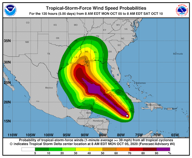
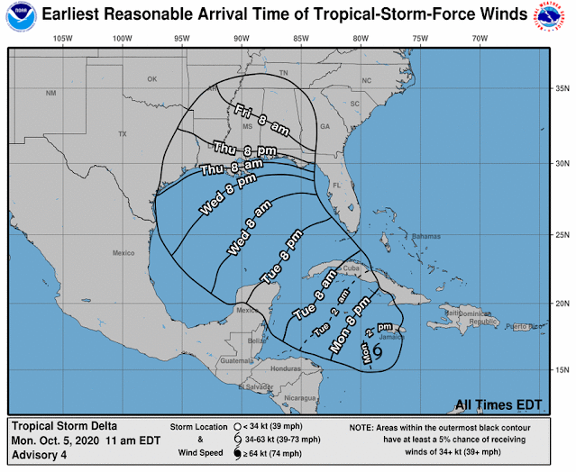
Tropical Storm Delta was approximately 135 miles south of Negril, Jamaica, as of 10 a.m., and approximately 265 miles southeast of Grand Cayman. The long-term track, which often changes, has the storm making landfall Friday near Terrebonne and Lafourche parishes and then turning east toward New Orleans and then heading into Mississippi.
At 7 mph, the storm is going west. Speed is expected to pick up on Tuesday and Wednesday. The core of the storm is predicted to move away from Jamaica later in the day on the forecast route, move close to or over the Cayman Islands on Monday night, and reach the Isle of Youth and western Cuba on Tuesday afternoon or evening.
In the Caribbean Monday morning, Tropical Storm Delta was strengthening and is predicted to become a hurricane Tuesday on its way towards Louisiana, forecasters said.
In southeast Louisiana, the latest track from the National Hurricane Center has Delta making landfall Friday as a Category 2 hurricane, but this far away, the route has an average error of 160 to 200 miles.
Depending on the direction and strength of the system, heavy rain, hazardous storm surge, and gusty winds are all possible along the coast from Louisiana to the western Florida panhandle, forecasters said. For residents, now is the time to make arrangements and prepare.
Tropical Storm Gamma, weakening in the Gulf of Mexico, is also being watched by forecasters. It is near the peninsula of Yucatan and is not supposed to enter the U.S. Gulf Coast.
Forecasters said the long-term track becomes complex because they are unsure how Tropical Storm Delta will interact with the remnants of Tropical Storm Gamma.
The interaction "could result in a sharp westward jog, after which a sharp turn back toward the northwest could occur," according to Stacy R. Stewart, a senior hurricane specialist with the National Hurricane Center.
The latest track from the National Hurricane Center has the system moving into the southeastern Gulf of Mexico Tuesday night or early Wednesday.

Popular Maps
-
How do we measure air quality?
-
 Why is the Air Quality reading on Weather.com consistently different than AirNow and AirVisual? Via my phone's default weather app, whic...
 -
In the adrenaline-fueled realm of storm chasing, a select group of individuals stand out as pioneers and experts in capturing nature's m...
-
Imagine a world where the electrical grid, the backbone of modern civilization, collapses entirely. No lights, no internet, no functioning ...
-
Throughout its history, the United States has faced catastrophic events that reshaped its society, economy, and institutions. From deadly ...
-
Planning for tomorrow’s weather is more than convenience — it impacts agriculture, shipping, aviation, and even local events. But not all w...
-
 California’s Era of Unrelenting Crisis Since Gavin Newsom took office in January 2019, California has endured one of the most expensive an...


-06-27-2023.png)


