Showing posts with label Wind. Show all posts

Pacific Palisades Fire, Evacuation & Wind Direction Maps

Report New Fires Here

LA County Fire Map Palisades


Rustic Canyon to Temescal Canyon

An evacuation ORDER has been issued for the Palisades Fire, Zone SSM-U010-A. Evacuation WARNINGS for zones SSM-U010-B, TOP-U007, and TOP-U009. Heres a link to the interactive evacuation map:

How Wind Shear Will Weaken Hurricane Milton as It Moves Northeast

As Hurricane Milton continues its path northeastward, meteorologists are predicting that the storm will weaken, largely due to a phenomenon known as wind shear. This natural atmospheric process plays a critical role in reducing the intensity of tropical storms and hurricanes, and understanding how it works can help explain the forecasted weakening of Hurricane Milton.

What is Wind Shear? 

Live Hurricane Idalia Video & Updates

Hurricane Idalia made landfall today at 8:00 a.m. Eastern.  Here are some videos of storm chasers.  Hurricane Idalia storm surge videos. 

Storm Surge Videos in Cedar Key & Perry Florida Hurricane Idalia

Record-setting storm surge at 6.5 feet.  Not a lot of rain but a tremendous amount of wind.  

Here are some images of hurricane boat damage. 

Hawaii's Warning System Failed is Deadliest Wildfire in 100 Years


The wildfires that broke out on the island of Maui are confirmed to be the deadliest in the United States in more than 100 years. As FEMA and the governor surveyed the damage, search teams continued to scour the ruins of historic Lahaina on Sunday. NBC News’ Tom Llamas has the latest.

Hurricane Ian Map with Wind Speeds

Hurricane Ian Map with wind speeds
Daily wind speeds and tracking map of where the Hurricane Ian storm is headed

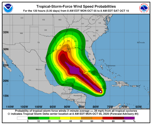
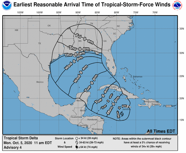
Gulf of Mexico Tropical Storm Delta Expected to Become Hurricane

Hurricane Delta wind forecast map NOAA
Hurricane Delta Landfall time NOAA

Tropical Storm Delta was approximately 135 miles south of Negril, Jamaica, as of 10 a.m., and approximately 265 miles southeast of Grand Cayman. The long-term track, which often changes, has the storm making landfall Friday near Terrebonne and Lafourche parishes and then turning east toward New Orleans and then heading into Mississippi.

At 7 mph, the storm is going west. Speed is expected to pick up on Tuesday and Wednesday. The core of the storm is predicted to move away from Jamaica later in the day on the forecast route, move close to or over the Cayman Islands on Monday night, and reach the Isle of Youth and western Cuba on Tuesday afternoon or evening.

In the Caribbean Monday morning, Tropical Storm Delta was strengthening and is predicted to become a hurricane Tuesday on its way towards Louisiana, forecasters said.

In southeast Louisiana, the latest track from the National Hurricane Center has Delta making landfall Friday as a Category 2 hurricane, but this far away, the route has an average error of 160 to 200 miles. 

Depending on the direction and strength of the system, heavy rain, hazardous storm surge, and gusty winds are all possible along the coast from Louisiana to the western Florida panhandle, forecasters said. For residents, now is the time to make arrangements and prepare.

Tropical Storm Gamma, weakening in the Gulf of Mexico, is also being watched by forecasters. It is near the peninsula of Yucatan and is not supposed to enter the U.S. Gulf Coast.

Forecasters said the long-term track becomes complex because they are unsure how Tropical Storm Delta will interact with the remnants of Tropical Storm Gamma.

The interaction "could result in a sharp westward jog, after which a sharp turn back toward the northwest could occur," according to Stacy R. Stewart, a senior hurricane specialist with the National Hurricane Center.

The latest track from the National Hurricane Center has the system moving into the southeastern Gulf of Mexico Tuesday night or early Wednesday.

What Is A Derecho?

Derecho storm cloud Iowa

According to the National Weather Service, a derecho storm is a widespread, long-lived wind storm that is accompanied by a band of rapidly changing showers or thunderstorms. A derecho is a group of long-lived winds and storms associated with rapidly changing thunderstorms or showers. Derecho is the name for a wide range of widespread and long-lived wind storms, which are linked in bands with rapidly changing showers and thunderstorms.    

Iowa Derecho Storm Maps & Damage


Huge storms produced widespread hurricane-like severe wind damage across Iowa, northern Illinois, and northern Indiana during the day on Monday, August 10. Much of this severe wind was significant (75+ mph winds) resulting in many downed trees, several toppled-over semi-trucks, cornfields, and many communities receiving at least some minor structural damage. Within the broader area of severe winds, 15 tornadoes were confirmed across northern Illinois and northwest Indiana.  What is a Derecho?

Popular Maps