

Showing posts with label ESRI. Show all posts
Showing posts with label ESRI. Show all posts
Best Air Quality Maps Near Me - Mobile Web Apps
Air Quality Aware - Esri
ESRI Uses Map Data from Air Now
Esri, a mapping software platform based in California, said this week that it has introduced a new app, Air Quality Aware, which helps people understand the air quality in their city. The new all uses data from the EPA's AirNow program and the NOAA's National Weather Service, along with the American Community Survey. The new all-show areas, according to the organization, are color-coded according to the Air Quality Index of the EPA, with magenta and purple reflecting harmful and extremely unhealthy air quality.
The new web-based map joins other utilities such as PurpleAir, allowing users to see what air quality is in their area, as well as various local government agency locations. In recent weeks, interest in monitoring air quality has increased dramatically, as wildfires in the Western US have brought air quality to its worst in decades in many areas; smoke from those fires has now entered Europe.


Sonoma County Fire, Shelters, Salvation Army, Red Cross Map
Active Fire Locations, Food Pantries, Shelters, Salvation Army and Red Cross
Map of Anaheim Canyon Fire Evacuation Areas
Map of the Canyon Fire Perimeter, Evacuation Centers, Damaged Homes
Florida Income Map - Red Cross, Salvation Army, Food Pantries
Florida Income Map of Red Cross, Salvation Army, Food Pantries & Shelters
Click Here for the Gas Buddy Real-Time Gas Prices and Availability Map
Here are some other maps to consider from the NY Times.

Click Here for the Gas Buddy Real-Time Gas Prices and Availability Map

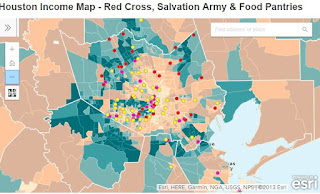
Houston Income Map - Red Cross, Salvation Army & Food Pantries
Houston Income Map with Red Cross, Salvation Army & Food Pantries
Houston Flood Reports Map & Disaster Relief
Houston 311 Flood Reports and Red Cross, Salvation Army & Food Pantries


Popular Maps
-
 Canada Wildfires 2026: What Caused the Fires, Where They Are Burning, and the Growing Disaster Threat Map: Natural Resources Canada’s Canad...
-
Security fencing can seem like a fairly straightforward decision until you start looking at the site properly. A fence around a warehouse y...
-
Planning for tomorrow’s weather is more than convenience — it impacts agriculture, shipping, aviation, and even local events. But not all w...
-
In Florida, mandatory evacuations are issued when a serious threat to life and property is imminent, typically due to natural disasters like...
-
 Flash floods are one of the most dangerous weather events, often occurring with little warning and resulting in severe damage. Flash flood...
-
 Public Perception Maps vs Actual Lava Flow on Hawaii Big Island Hawaii VOG Map If you are planning to vacation or li...
-
 Are Natural Disasters Increasing? What 10 Years of Hurricanes, Tornadoes, Floods and Wildfires Tell Us Natural disasters can make almost any...
-
 The Hungarian RSOE and Its Emergency and Disaster Information Service (EDIS) Introduction When disasters strike, the difference between ...


