Showing posts with label Forecast. Show all posts

How AI Is Being Used for Disaster Forecasting

From Physics to AI

For decades, disaster forecasting relied mainly on physics-based numerical models. These systems use supercomputers to solve complex equations simulating atmospheric and geological processes. While powerful, they take hours to run, limiting how quickly forecasts can be updated.

Artificial Intelligence (AI) is now reshaping this process. By analyzing decades of historical data and real-time sensor inputs, AI models can generate forecasts in seconds. They not only provide faster results but also detect patterns and anomalies that traditional models often miss. Instead of replacing physics models outright, AI augments them—giving decision-makers the best of both worlds: speed and accuracy.

Weather Extremes: Hurricanes and Severe Storms 

Weather Tomorrow: The Most Accurate Forecast Services Ranked

Planning for tomorrow’s weather is more than convenience — it impacts agriculture, shipping, aviation, and even local events. But not all weather apps and services are equal. Independent evaluations show wide gaps in accuracy, especially for short-term forecasts. So which weather provider is most accurate for tomorrow’s forecast? Let’s explore the rankings and why they stand out.

Why Forecast Accuracy Matters

How Wind Shear Will Weaken Hurricane Milton as It Moves Northeast

As Hurricane Milton continues its path northeastward, meteorologists are predicting that the storm will weaken, largely due to a phenomenon known as wind shear. This natural atmospheric process plays a critical role in reducing the intensity of tropical storms and hurricanes, and understanding how it works can help explain the forecasted weakening of Hurricane Milton.

What is Wind Shear? 

Good News: Hurricane Kirk to Stay Out at Sea, No Threat to Land

In a welcome turn of events, Hurricane Kirk, which had been closely monitored by meteorologists for days, is not expected to make landfall. The storm, which initially raised concerns due to its rapid development and projected path, has fortunately changed course, staying well away from populated areas. This is great news for communities that were bracing for potential impacts, as Hurricane Kirk will remain far out at sea, sparing coastal regions from any significant threats.

Hurricane Kirk's Path Changes for the Better

Gulf of Mexico Tropical Storm Delta Expected to Become Hurricane

Hurricane Delta wind forecast map NOAA
Hurricane Delta Landfall time NOAA

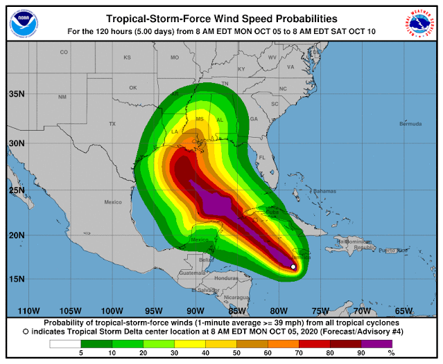
Tropical Storm Delta was approximately 135 miles south of Negril, Jamaica, as of 10 a.m., and approximately 265 miles southeast of Grand Cayman. The long-term track, which often changes, has the storm making landfall Friday near Terrebonne and Lafourche parishes and then turning east toward New Orleans and then heading into Mississippi.

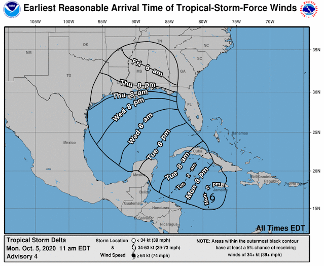
At 7 mph, the storm is going west. Speed is expected to pick up on Tuesday and Wednesday. The core of the storm is predicted to move away from Jamaica later in the day on the forecast route, move close to or over the Cayman Islands on Monday night, and reach the Isle of Youth and western Cuba on Tuesday afternoon or evening.

In the Caribbean Monday morning, Tropical Storm Delta was strengthening and is predicted to become a hurricane Tuesday on its way towards Louisiana, forecasters said.

In southeast Louisiana, the latest track from the National Hurricane Center has Delta making landfall Friday as a Category 2 hurricane, but this far away, the route has an average error of 160 to 200 miles. 

Depending on the direction and strength of the system, heavy rain, hazardous storm surge, and gusty winds are all possible along the coast from Louisiana to the western Florida panhandle, forecasters said. For residents, now is the time to make arrangements and prepare.

Tropical Storm Gamma, weakening in the Gulf of Mexico, is also being watched by forecasters. It is near the peninsula of Yucatan and is not supposed to enter the U.S. Gulf Coast.

Forecasters said the long-term track becomes complex because they are unsure how Tropical Storm Delta will interact with the remnants of Tropical Storm Gamma.

The interaction "could result in a sharp westward jog, after which a sharp turn back toward the northwest could occur," according to Stacy R. Stewart, a senior hurricane specialist with the National Hurricane Center.

The latest track from the National Hurricane Center has the system moving into the southeastern Gulf of Mexico Tuesday night or early Wednesday.

Popular Maps