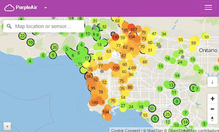
3 Real Time Maps of LA's Current & Future Air Quality & Wind
Related Articles:
Air Quality,
Calfire,
California,
Fire,
Google Maps,
Los Angeles,
Ventura
Popular Maps
-
Florida, known for its sunny beaches and warm climate, is also one of the most hurricane-prone states in the U.S. Understanding Florida'...
-
Imagine a world where the electrical grid, the backbone of modern civilization, collapses entirely. No lights, no internet, no functioning ...
-
According to the National Weather Service, a derecho storm is a widespread, long-lived wind storm that is accompanied by a band of rapidly c...
-
Natural disasters are unavoidable and prevalent in human history, but it doesn't diminish our collective shock when they strike. Her...
-
California’s Era of Unrelenting Crisis Since Gavin Newsom took office in January 2019, California has endured one of the most expensive an...
-
Planning for tomorrow’s weather is more than convenience — it impacts agriculture, shipping, aviation, and even local events. But not all w...
-
Earthquakes are sudden reminders of the Earth’s restless nature. In 2020, while the world’s attention was focused on the global pandemic, ...
-
How To Subscribe Visit the DisasterReliefMaps.com website. Sign in using your Google account to instantly access our extensive disaster...
-
Typhoon Ragasa has emerged as one of the most powerful storms of the year, drawing the attention of millions across Southeast Asia. The typh...
-
Natural disasters have increasingly shaped the trajectory of urban development and resilience...
Topics
Fire
California
Hurricane
Calfire
Flood
Evacuation
Florida
Shelters
Google Maps
How To
Storm
Smoke
Weather
Air Quality
Map
Tornado
Government
ESRI
FEMA
Los Angeles
Earthquake
Wind
Insurance
Oregon
Hurricane Helene
Hurricane Ian
Video
Arson
Colorado
Hawaii
Iowa
Oklahoma
Red Cross
Salvation Army
Chasers
Data
Food Pantry
Forecast
Hurricane Harvey
Hurricane Milton
Midwest
Africa
Climate
Derecho
Hurricane Idalia
Live
Mobile App
Oil
Power
Satellite
Texas
Top10
Ventura
Volcano
Washington
AI
Canada
Cell Phone Towers
Coronavirus
CrisisMap
Fake News
Gulf of Mexico
Homeless
Louisiana
Puerto Rico
Radar
Tsunami
United Nations
United States
War
Alabama
Australia
Bel AIr
Beverly Hills
Calabasas
Caribbean
Cyclone
EPA
Gavin Newsom
Google
Houston
Hurricane Ida
Hurricane Laura
Hurricane Sally
Malibu
New Orleans
North Carolina
Orange County
Palisades
Prepare
Santa Clarita
Santa Monica
Santa Rosa
Sonoma County
Taxes
The Getty
Thousand Oaks
Trump
Typhoon
Virginia
Water
Wisconsin
Aerial
Anaheim
Antarctica
Arizona
Bahamas
Border
Camp
Canyon
Crash
Damage
Deductions
Explosion
Gas Buddy
Georgia
Greece
Hail
Hurricane Delta
Hurricane Dorian
Hurricane Florence
Idaho
Income
Kansas
Kentucky
LA Times
Mississippi
Missouri
Mudslide
NOAA
Napa
Nebraska
New York
Planning
Pollution
Poverty
Power Lines
Redding
Refinery
Relief
Sacramento
Skirball
Starlink
Strange
Sylmar
TV
Terrorist
Toxic Waste
Traffic
Trees
Ukraine
Westlake
Woolsey
Yorba Linda
Zogg


