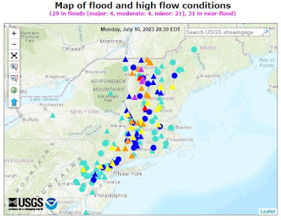
Torrential downpours and extensive flooding caused widespread devastation in the river valleys and mountainous regions of Vermont and New York State on Monday.
The impact drew parallels to the destruction caused by Tropical Storm Irene over a decade ago.
Heavy downpours have been flooding homes and washing away roads and bridges in parts of the Northeast. Water rescue teams rushed to Vermont on Monday after the rain made some towns unreachable by road.
The storm wreaked havoc in New York on Sunday, particularly in the Hudson Valley, where some areas experienced up to eight inches of rainfall, resulting in one fatality. By Monday, the storm's center had shifted to Vermont, placing the landlocked and mountainous state at high risk of severe flooding. This situation mirrored the circumstances during Tropical Storm Irene, which also targeted tiny, isolated towns along rivers and creeks.
Governor Phil Scott of Vermont expressed concern that the volume of water brought by this week's storm system could surpass that of Irene. During Irene, six people lost their lives in Vermont. The prolonged duration of the current rainstorm, expected to last several days, intensifies the governor's apprehension.
Governor Scott highlighted the difference between the two events, emphasizing that Irene lasted approximately 24 hours, whereas the current storm is delivering comparable, if not greater, rainfall over an extended period. He stressed that the prolonged impact is what deeply worries him, as it increases the potential for substantial damage beyond the initial effects.
Flood Map Vermont & New Hampshire
Serious, life-threatening flooding is occurring today across much of Vermont. Emergency crews have conducted rescues in multiple communities. About two dozen state roads are closed as of 10AM. Flash flood warnings are in effect from the Massachusetts line to the Canadian border. pic.twitter.com/09ryZ1N7bR
— Vermont State Police (@VTStatePolice) July 10, 2023


